Yesterday was the 56th day in a row that I went for a walk in the morning. I don't ever set an alarm, because if I weren't to wake up in time for a walk I figure I need my sleep more than I need a walk, not to mention that an alarm would also probably wake up small people, which would mean that it wouldn't be as easy as I would like to get out for a walk on my own. Since I like to be home by about 7:00, 7:30 at the very latest, because of the heat once the sun has been up for awhile, the length of my walk generally depends on what time I got going. The last few weeks I've gone eight kilometers almost every day, sometimes a little more or a little less, one day just three because I wasn't up until after 6:30. Last Sunday I walked all the way around the Salt Lake (about 11 kilometers) and really wished I had my camera, so when I was up at 5:00 yesterday, I decided to go again, with a camera. This first photo was taken from the front steps of our house at 5:04 a.m. (If you're one of those people who know how to figure out when a photo was taken and bother to check, yes, I KNOW I need to change the time on my camera...)

Just after I reached the nature trail (just to the left of the middle--the trail is four kilometers long) and turned right, to walk around the lake counter-clockwise. The lights are at the airport.

It's nice and cool in this "tunnel", wonderful in Cypriot July.

Turning and looking behind me about 500 meters from the end of the trail, about 5:20 a.m.

The aquaduct at the end of the trail. After this I was on various roads and paths through fields. The first time I walked all the way around the Salt Lake (three weeks ago), I was often not exactly sure if I was in the right place until I reached another landmark, but it was actually quite easy to figure it out and I never did make any wrong turns.

This sign looks nice and official, anyway...

Take the left-hand one. They stay more-or-less parallel for a bit, but then the right-hand one veers off sharply to the right.

5:40--it was perfectly light, but the sun wasn't quite visible yet.

I found these fence posts amusing. I guess they serve as a visual aid of the boundary to the wildlife conservation area.


A somewhat less than useful sign, since there wasn't really any other way to go...

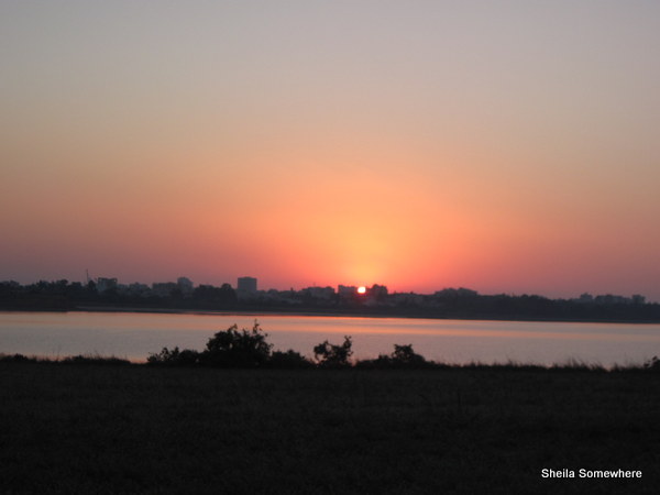
Sun starting to appear over Larnaka at 5:45.
First view of the Hala-Soultan mosque.

An even less-useful sign post than the previous one, seeing as it's kind of anybody's guess which two of the three possible directions might have originally been meant...

For your reading pleasure if you feel like zooming.

A dairy farm, from the sound and smell. I didn't actually see any cows, though.

The mosque closer up.

And looking back at the mosque after having passed it.

When this bench was installed, nobody apparently expected the water to get as high as it did this winter. Three weeks ago the water was still lapping at the concrete under the bench, and a friend told me a few days ago that during the winter, the bench was actually submerged.

It took me 49 minutes to walk this distance, counting the stopping to take photos.

The walk along the airport road isn't so nice, because of being on pavement, along a busy road, and with little to no shade. This is looking back at the round-about to the old airport.

One of the little salt lakes across the main road from the big one, which is already dried up. I'll be very surprised if the big one dries up this year, though.

At the old airport round-about I crossed the road, because from there to where I turn off, there's a little bit of shade on the right-hand side of the road, none at all on the left.

Finally back to the nature trail.

And another blurry photo of the mosque, from the other side of the lake...

There were some offical looking vehicles on the road between the mosque and the airport road, with men wearing gas masks spraying something into the Salt Lake, which I'm guessing was pesticide, but don't know. I gave them a fairly wide berth and didn't think of taking photos. Then I saw some more of the same vehicles parked, and several men walking around in the water scattering something. Any ideas?

Several months ago, concrete blocks appeared on both sides of the trail at 500 meter intervals. After several weeks, a frame was added on the slanted tops, and pieces of stone were put around the sides. After another couple of weeks or so, mortar was put in between the stones on the sides. That was at least a month ago now, and I took a photo of one of them on the walk. Not very exciting, but I do like having markers every 500 meters.

A last photo of the Salt Lake before leaving the nature trail to head home.

And a final photo while sitting on our front steps, at 7:06 a.m.

Mommy, it was mosquito poison. I read about it an the newspaper some weeks ago that the moquito population was getting dangerous, so the government is spraying breeding grounds.
ReplyDelete